A new homeowner in Texas recently found themselves in an expensive dispute with their neighbor after putting up a fence. It looked like a simple improvement that turned into a legal headache because the fence had been built a few feet beyond the actual property line. The problem wasn’t the fence itself, but was lack of a professional land survey before the work began.
Situations like this happen more often than people think. Boundaries can look obvious, but property lines are not as simple as a fence, a hedge, or a driveway. That’s why a land survey becomes important to know.
What is a Land Survey?
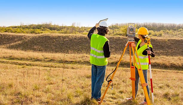
A land survey is a professional measurement that defines the exact boundaries, features and legal lines of a property.
It simply means having a certified record of where your land begins and ends. A surveyor uses special tools and historical land records to map the land. The results are written and saved in a legal survey report and map. This information can be used in real estate transactions, construction projects and even legal disputes.
A land survey reveals:
- Structures like houses, driveways, or fences.
- Easements that give access to utilities or neighbouring properties.
- Rights-of-way or restrictions that affect land use.
- Natural features like slopes, creeks, or trees.
Property lines can look easy, but history and things like outdated maps complicate things. A surveyor can give clarity that is backed by legal authority.
Related: How to Flip Houses with No Money: 10 Smart Strategies
Different Types of Land Surveys
Not all surveys have the same goal. The type of land surveys you need depends on what you’re doing with the property.
These are the most common ones:
1. Boundary Survey
- Marks the exact property lines and corners.
- Mostly used when building fences, settling neighbor disputes, or confirming the ownership, where it begins and ends.
- For example, two neighbors disagree on who owns a strip of grass between their driveways. A boundary survey will solve the argument with legal clarity.
2. Topographic Survey
- Maps the natural and man-made features of the land. It includes slopes, trees, and drainage.
- Usually used by architects, engineers, or contractors before starting construction.
- For example, a builder uses a topographic survey to design a home that has a sloping backyard.
3. ALTA/NSPS Survey
- A detailed survey is used for commercial real estate transactions.
- Covers boundaries, easements, improvements, and risks that lenders and insurers need to see.
- For example, a developer purchasing a shopping center orders an ALTA survey to make sure the property is clear of hidden restrictions.
4. Subdivision Survey
- Breaks the big part of the land into smaller lots for sale or development.
- Needed by local authorities before new neighborhoods or communities can be created.
5. Mortgage or Title Survey
- A simple survey needed by lenders before approving a home loan.
- Confirms that the property being financed matches the legal descriptions and records.
Related: How to Invest in Bitcoin: 2025 Beginner’s Guide
When Do You Need a Land Survey?
A land survey is necessary when buying or selling property. It makes sure that the land matches the legal description and helps both parties to avoid any kind of disagreement about size, boundaries, or ownership.
Construction Projects
Surveys are needed before starting any projects. If it’s a new house, a garage, or even a fence, building permits need an updated survey to confirm that the structure is within the legal limits of the property.
Boundary Disputes
These problems between neighbors are another common reason. A disagreement about where a fence, tree line, or driveway sits can quickly escalate, and a professional survey provides the legal documentation needed to solve the conflict.
Land Development Projects
They depend on surveys as well. Subdividing a large part of land into smaller lots or planning new infrastructure needs right mapping for zoning and planning regulations which are set by local authorities.
Many lenders and banks ask for a survey before approving financing. This makes sure that the property matches the official records and does not have risks that can affect the value.
Related: What is a Title Report? Everything You Need To Know
How Much Does a Land Survey Cost?
The cost of a land survey is between $300 and $1,000, with the national average hovering around $500. This range can change depending on the size of the property, and the type of survey needed.
1. Property Size
The size of a property is one of the strongest indicators of cost. A small residential lot in a city will take only a few hours to survey, but a big rural land that covers multiple acres needs far more time and resources. More acreage means more boundaries to measure. This mostly pushes the price higher.
2. Location
The property’s location also affects how much a survey costs. Urban lots are easier to document because they have clear boundaries and existing public records. Rural properties sometimes have outdated maps or unclear records. This forces the surveyors to spend more time in the field. Remote areas with limited access also add to the difficulty and cost.
3. Type of Survey
Not all surveys are the same, and the type you need has a big impact on pricing. A straight boundary survey that marks property lines is very affordable. But, an ALTA/NSPS survey, which is far more detailed and commonly used for commercial properties, can cost some thousand dollars. This level of detail directly pushes the cost higher.
4. Ground Area
The physical layout of the land is also important in survey pricing. Open, flat lots are easy to measure, but heavily wooded, or hilly properties take longer to map. Surveyors need extra tools and techniques to handle difficult terrain. This raises the time investment and, then, in the overall cost of the project.
5. Property Records
Past survey records can help reduce the cost of a new survey. When documents are available, a surveyor can use them as a reference to save both time and labor. But, when old records are missing, incomplete, or incorrect, it takes more time to research deeds, compare old maps, and take extra measurements. This also increases the final bill.
6. High Costs
For large properties, surveys can go up to $2,000 and sometimes even reach $5,000 or more. This happens with commercial projects, bigger rural properties, and parts of land that need to be broken. While the price might look high, a right survey provides legal protection and prevents costly disputes or construction errors later. In many cases, the expense of the survey is far less than the cost of fixing boundary problems down the line.
Related: Step-by-Step Land Development Checklist
Leonard Developments
We take up every project with careful planning, starting with a detailed understanding of the land. Accurate surveys are necessary to identify boundaries, easements, and terrain features before any construction begins.
Our team works closely with clients to make sure the survey process is clear and reliable. By connecting property owners with experienced surveyors and looking at results carefully, Leonard Developments helps prevent disputes, design errors, and costly delays.
Our focus is on using the right information to make informed decisions. This approach helps every project to begin with a strong foundation, both legally and structurally.
Final Thoughts
A land survey helps in defining property boundaries, possible problems, and giving legal clarity. When you buy a home, build an addition, or develop land, remember to have an accurate survey done. It will protect both time and investment.
Costs can change based on property size, location, terrain, and the type of survey required. Investing in a professional survey helps in avoiding disputes, construction errors, and legal complications that could be far more expensive later.
Working with experienced surveyors makes sure of precision, while taking steps to gather records, choose the right survey type, and plan carefully can help manage the costs. These help in providing both financial and legal confidence for property owners.
Leonard Developments emphasizes the importance of starting every project with the right land information. By combining professional surveys with careful planning and expert guidance, clients can move forward knowing their property decisions are informed, safe, and well-documented.